Thursday, October 17, 2013

Last Stop - Norway

Norway is the land of my forefathers on my dad's side.  The Skovlin Farm is still active today in the south part of Norway.  Someday I'll visit it, but this trip was to Trondheim towards the north (latitude 65 degrees).  We stayed with friends from the University of Trondheim.

Trondheim, Norway

Typical northern Norway countryside.
Our friends treated us to a visit to their cabin about 2 hours north of Trondheim. Unfortunately, there were road problems so we had to take the 4-hour route.  The countryside is so beautiful with green rolling hills, white houses and red barns. It really is surreal.  Small villages dotted the way and we finally got into the highlands which were really more like tundra.  I was very excited to spot some caribou only to find that they are semi-domestic.

We parked the car on the side of the road and hiked our gear to the cabin about a half kilometer. Wow, the cabin was spectacular!  Nestled by a large lake, the grass-roof "cabin" is really three buildings; two self contained cabins and an outhouse.  Heat was by several wood stoves, cooking and fridge are gas and lights from a small solar system!   The latitude is so high they mount the solar panes on the wall instead of roof.


The following day we went on a big hike up the mountain behind the cabin.  It's was stunning with a tundra landscape dotted with lakes and pure flowing streams. There was still a little snow on the ground and the water was icy, but the day was nice and warm.

Oh man, was that cold!
Hiking across the Nordic tundra.

Denmark is green!

Three main islands of Denmark
We stopped in Denmark to visit friends from our stay in Thailand in 1994-96. Danish people are kind, fun and thoughtful. They have a lot of progressive policies from social services, to environmental management. 
There are three main areas of Denmark, a large peninsula (Jutland) and two big islands (Funen and Zealand). Copenhagen is on Zealand. There are only about 5.8M people in the country whose history was shaped by Vikings and sea-going trade.
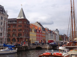
Copenhagen is Denmark's capitol with 1.2M people, relatively small by world standards.  Clever and forward thinking planners have limited the height of buildings so the skyline is made up of historic spires and castle parapets instead of skyscrapers. It has a fantastic effect that connects one to Denmark's history!

Copenhagen skyline preserves historical view.
The best ways to travel in Copenhagen is by bike, foot or boat.
It is a very agricultural country with quaint farms on green, green pastures and windmills are part of the landscape. We thoroughly enjoyed eating fantastic cheese.

Frederiksborg Castle Hillerod Denmark

Every castle needs a moat ornament


We spent some time touring the local castle near our friend's home. It was built in 1,400 by King Christian IV. It was really spectacular and presented a good overview of Denmark's history through to the present day Monarchy, Queen Margaret.  

It was quite expensive for US travelers so we were grateful to be staying with our friends. 

Monday, May 20, 2013

Cappadocia, Cappadocia, Cappadocia

Friends from Corvallis told us that their trip to Cappadocia was the best part of 2012 and that was a good enough endorsement for us so off we went.  Getting off the plane you noticed the fresh, light air.  We never did put our finger on why, but the whole visit was relaxing.

Cappadocia is a region in central Turkey that was first settled before the bronze age. We visited a little tiny museum with axes dated 5,500-8,000BC! Christians occupied the area in the 2nd century and built extensive dwellings in the strange volcanic geologic formation and in the hillsides.  They were hiding from persecution by the Romans.  Underground cities were built out of the tuft formations that extended 70m (200feet) below the ground.  We toured a cave that had a community of 1,000 people and their donkeys.  It was very elaborate with ventilation tunnels, wells, rolling-stone doors and a labyrinth of rooms including churches, kitchens and stables.
Our view from the Cave Hotel of the city of Urgup
Pyroclastic volcanic eruptions created deep layers of soft tuft
overlain by basalt that eroded to form an eerie landscape.
The cities are built on, in and under the tuft formations.
Cappadocia is an agricultural region where famous
Anatolian wool carpets come from.

A typical street scene.  Women hang out in groups chatting
while the men sit around tables playing cards and backgammon.

The view we woke up to on our last day!

Vineyards are 4,000 years old in Cappadocia
making for some delicious wine!
A church built in a cave from 400-800AD..


Friday, May 17, 2013

Amazing Istanbul

Blue Mosque with six minarets
Istanbul is one of my all time favorite places.  The history is so rich, well preserved and openly on display.  The Roman Empire, Alexander the Great, Constantine, Byzantine, Ottoman Empire, Sultans and grand viziers come alive all around you. In addition to the incredible structures they built through the ages, they "acquired" artifacts during their conquests around the region and brought back to Istanbul. It's not unusual to see relics that are 3,000-5,000 years old!!

Iznik tulip tiles
Mosques and palaces seem to be everywhere and are just breath taking in their scale.  Scott and I literally spent an entire day touring just the Topkapi Palace, the center for governance during parts of the Ottoman Empire. At it's peak, 10,000 people a day were fed at Topkapi Palace. It had a Harem with over 1,000 concubines, 300 rooms, a school and a hospital.  Topkapi Palace is home to the Staff of Moses, the hand of John the Baptist, King David's sword, and the Prophet Mohammed's mantle (cape) along with his hair and impressions of his footprint.

The city was established in 667 BC and was known as Constantinople until Ottoman Empire took over in the 1,400s (AD). Today the city is incredibly diverse and walking down the street you will see women in full burkas, headscarves and western clothes.
Typical street scene


Istanbul-Bosphorus in background


Istanbul straddles the continents of Europe and Asia which are separated by the Bosphorus, a natural waterway between the Black Sea and the Marmara Sea (and Mediterranean Sea). The Bosphorus made Istanbul easily defensible and wealthy because of its importance for the trade of wine and olive oil from the Mediterranean region for grain, skins, wool and timber from the Black Sea region (Russia). On an hourly basis, the Bosohorus changes its mood from black to emerald green and glacial blue.

Egyptian obelisk from 3,000BC at one end of the
Hippodrome where they had chariot races.
Inside Suleymaniye mosque
Haghia Sophia was built as a church in 537AD
by Emperor Justinian.  It is considered one of the
greatest architectural achievements in the world.
  In the 15th century it was converted into a mosque.

Byzantine mosaic fresco from 1,300 AD


Thursday, May 9, 2013

Thailand for Sanuk*


Arriving in Thailand was like coming home.  It is so relaxed and we feel so comfortable, not to mention we could fit two of our Tokyo apartments into our hotel room! Thai people love to have fun and enjoy themselves and it is evident everywhere.
 
The economy is booming and more builidings are popping up everywhere. But, somethings haven't changed, Bangkok as busy as ever, the temples are still spectacular and the klongs (waterways) are still polluted.

Pollution-free skies in Bangkok!!
One great surprise was how clear the air is! In 1995 there were times that you couldn't see the skyscrapers for the pollution. Now you can see the highrises all the way to the horizon! That is a huge accomplishment for Thailand. The progress is through the development of a overhead Skytrain, improvements in vehicle emissions the fact that Thailand has a supply of natural gas (LPG) that all the taxis have switched to. There are certainly a lot of cars still on the road. Last night we went to dinner, it took us 90 minutes to get there in rush hour traffic and 20 minutes to return. It was nostalgic and well worth it for delicious Thai food and seeing old friends!


Wat Arun (Temple of the Dawn)
Wat Pho


We spend a couple days touring around in Bangkok and then down to Kho Samui, a beautiful island with picturesque beaches. We completely relaxed! Now we are back in Bangkok and visiting friends. Thai people are the friendliest in the world!!


The beach at San Suoci Hotel
"Our" table where we ate all meals.


*Sanuk is a complicated word that means enjoying oneself and putting fun first regardless of what you are doing.  It is a unique word that applies to work and play.  Thai people are masters at sanuk!


Presentation is everything,
this is a melon, cantaloupe and papaya.


Friday, May 3, 2013

The Great East Japan Earthquake Disaster

In late April we toured the area ravaged by the tsunami from the 2011 Tohuko Earthquake. The images of the advancing wall of black water filled with cars, houses and boats came surging back. I can't explain the feelings that went through me as we passed through vast areas that used to be bustling cities and are now nothing but foundations on empty lots. Because of the salt water, nothing grows and all but the a few sacred trees are standing, even fewer are still alive.

The magnitude 9 Tohuko Earthquake earthquake hit on March 11, 2011 and caused enormous damage in the Tohuko and Kanto Regions. Damage was from shaking and the following tsunami which was much worse than ever predicted. Shaking in Tokyo (200 miles south) lasted 5 minutes. when in Castro Valley, California, we experienced the Loma Prieta earthquake that shook for 15 second and that felt like a lifetime!

The highest recorded water level from the tsunami was 9.3 meters (30 feet). The epicenter of the earthquake was deep in the ocean. The quake was caused by tectonic plate movement; one moving over the other. As well as the shaking and the tsunami, this caused (semi) permanent ground movement and subsidence on shore of up to 5.3 meters horizontally and 1.2m vertically.

15,782 people died and 4,000 are still missing (60% are over 60 years old). Over 300,000 homes were badly damaged or destroyed. The debris has now been cleared, but it is still unclear what will be done in the leveled areas that are no doubt susceptible to future tsunamis. The best solution that I heard was to prohibit construction in ares less than 6 feet in elevation. Businesses and commercial facilities could be built in the areas up to about to about 9 feet. Then plant a forrest that slows the progress of the tsunami, then a road on an embankment to an elevation of about 12-15 feet elevation and then finally homes. You don't need to be very good at math to realize that this won't be tsunami safe if another huge one hits, but somewhere you have to draw the line of risk vs. practicality. In most places the plan outlined would mean that homes would not be built within a quarter mile of the ocean! That's a lot of real estate.


This port building was so new it was never occupied before the tsunami wiped it out. A debris processing facility in the background.


Empty streets that used to be neighborhoods.


In the upper right side of this photo you can see the line of demarcation where the tsunami reached and above the homes are fine. They have left buildings like the one in the foreground for memory sake. Also, in the picture are the stages of waste clearing.

This statue of Kannon, the goddess of mercy, was established along the beach after the earthquake.


This was an iconic building that had become an ad hoc shrine. It was the Disaster Preparedness Office build to sustain tsunamis. The workers were so confident they evacuated to the roof, but were still washed away. We heard so many sad stories like this.

Japan Tsunami Disaster Waste Disposal

The Ishinomaki area about 200 miles north of Tokyo was hit the hardest by the 2011 tsunami that resulted from the Tohuko Earthquake. Over 3billion tons of debris will be processed.  The facility is about 100 acres.  Waste is stockpiled locally and then transferred to the Ishinomake facility.  It is the biggest facility.  Most communities were served by regional facilities like Ishinomaki.  Operation started in March of 2012 and must be complete by March 2014.  They are pretty much on schedule.

Material is first separated into concrete waste, wood waste, sediment and mixed waste (everything else).  The concrete, wood and sediment is sorted again, sifted, crushed, washed and prepared for reuse.  Mixed waste comes to the facility and goes through a rough separation process where mementos, hazardous materials and recyclable materials are removed.  It is then shredded, crushed and screened and incinerated.  There are five huge incinerators working all the time.  The ash from the incineration process is stabilized and used where possible.  Most reuse must be local on ports since people are worried about radiation.  However, this area also experienced about 3 feet of subduction due to the movement of the earth's plates so there is a lot of filling to be done!

At the Ishinomaki facility about 1,500 tons per day is processed.  The total cost of the facility is about $1.4 billion and is all contracted out to large consortia of construction companies.


Getting Around in Tokyo

Typical train station platform
The best way to get around in Tokyo is by train. Tokyo's extensive subway system is the best in the world and extremely convenient. Each ride costs around $2 and the typical trip requires a couple transfers so by the time you go somewhere and back home you've spent ten bucks. Certain periods of the day are incredibly crowded. One morning we took the train near our house at peak morning rush hour. There were hired guys pushing people into the train cars and our bodies were squished against other bodies all the way to the knees!

Packed Local Train
Peak hour in Tokyo Station


Generally people are either sleeping, reading or playing games on their phones, which is a convenient way to avoid eye contact when the train is packed.


Battery assisted Mom-mobile

Another great way to travel is by bicycle. We were in a pretty affluent area of Tokyo and most all the moms had battery assisted bicycles. Talk about soccer moms, these gals were vicious on their bikes loaded up with a couple kids and the day's shopping. Watch out!


My favorite were the folks that commuted by bicycle to the subway. At the subway station there are huge underground bicycle parking lots. Fantastic technology. I saw some that had bikes stacked several layers high in automated parking structures. You could pay by the hour or get a monthly parking pass. Wow!
Bicycle Park-n-Ride
Bike Park Entrance


And of course there is the Bullet Train (Shinkansen).  It is super comfortable and travels at between 150 and 200 mph!  It's hard to look at the scenary things are flying by so fast.  We took it to Kyoto, Kobe and then Sendai.  It is a little expensive, but beats going to the airport. 
The Bullet Train (Shinkansen)


Tokyo Subway Map